Back تاجايتاى Arabic Tagaytay BCL Tagaytay CBK-ZAM Tagaytay CEB Tagaytay City German Tagaytay French Tagaytay ID Tagaytay ILO Tagaytay Italian タガイタイ Japanese
Tagaytay | |
|---|---|
Tagaytay Picnic Grove Taal Vista Hotel Tagaytay Rotonda Cable Car in Tagaytay Highlands Tagaytay City Hall | |
| Nickname: Alternative Summer Capital of the Philippines | |
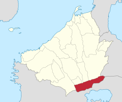
 Map of Cavite with Tagaytay highlighted | |
Location within the Philippines | |
| Coordinates: 14°06′N 120°56′E / 14.1°N 120.93°E | |
| Country | Philippines |
| Region | Calabarzon |
| Province | Cavite |
| District | 8th district |
| Foundation and cityhood | June 21, 1938[1] |
| Barangays | 34 (see Barangays) |
| Government | |
| • Type | Sangguniang Panlungsod |
| • Mayor | Abraham N. Tolentino |
| • Vice Mayor | Agnes D. Tolentino |
| • Representative | Aniela Bianca D. Tolentino |
| • City Council | Members |
| • Electorate | 54,743 voters (2025) |
| Area | |
• Total | 65.00 km2 (25.10 sq mi) |
| Elevation | 634 m (2,080 ft) |
| Highest elevation | 740 m (2,430 ft) |
| Lowest elevation | 292 m (958 ft) |
| Population (2020 census)[4] | |
• Total | 85,330 |
| • Density | 1,300/km2 (3,400/sq mi) |
| • Households | 22,399 |
| Demonym | Tagaytayeño |
| Economy | |
| • Income class | 2nd city income class |
| • Poverty incidence | 15.28 |
| • Revenue | ₱ 1,689 million (2022) |
| • Assets | ₱ 8,633 million (2022) |
| • Expenditure | ₱ 1,118 million (2022) |
| • Liabilities | ₱ 2,640 million (2022) |
| Service provider | |
| • Electricity | Manila Electric Company (Meralco) |
| Time zone | UTC+8 (PST) |
| ZIP code | 4120 |
| PSGC | |
| IDD : area code | +63 (0)46 |
| Native languages | Tagalog |
| Numbered highways |
|
| Major religions | |
| Feast date | February 11 |
| Ecclesiastical diocese |
|
| Patron saint | Our Lady of Lourdes |
| Website | www |
Tagaytay ([tɐgaɪˈtaɪ]), officially the City of Tagaytay (Filipino: Lungsod ng Tagaytay), is a component city in the province of Cavite, Philippines.[1] According to the 2020 census, it has a population of 85,330 people.[4]
It is one of the country's most popular destinations for domestic tourism because of its scenery and cooler climate provided by its elevation. Tagaytay overlooks Taal Lake in Batangas and provides views of Taal Volcano Island in the middle of the lake through various vantage points situated in the city.
The name Tagaytay is derived from the Tagalog words tagaytay or taytay, which mean "mountain ridge" or "low mountain range", in reference to the Tagaytay Ridge on which the city sits.[6]
- ^ a b Cite error: The named reference
CA338was invoked but never defined (see the help page). - ^ City of Tagaytay | (DILG)
- ^ "2015 Census of Population, Report No. 3 – Population, Land Area, and Population Density" (PDF). Philippine Statistics Authority. Quezon City, Philippines. August 2016. ISSN 0117-1453. Archived (PDF) from the original on May 25, 2021. Retrieved July 16, 2021.
- ^ a b Census of Population (2020). "Region IV-A (Calabarzon)". Total Population by Province, City, Municipality and Barangay. Philippine Statistics Authority. Retrieved July 8, 2021.
- ^ "PSA Releases the 2021 City and Municipal Level Poverty Estimates". Philippine Statistics Authority. April 2, 2024. Retrieved April 28, 2024.
- ^ Lesho, Marivic; Sippola, Eeva (2018). "Toponyms in Manila and Cavite, Philippines". Vergleichende Kolonialtoponomastik Strukturen und Funktionen kolonialer Ortsbenennung. De Gruyter. pp. 317–332. ISBN 9783110608618.


